Copernicus Marine Service Arctic MFC: Validation of near-surface drift
Validation results: Drifting buoy data
Color coding in scatter plots is used to indicate a separation between buoys: Each buoy has up to 17 results for daily drift in the Best Estimate validation, so the same color is used for each of the (up to) 17 points in the scatter plot that corresponds to this buoy. However, the number of colors used is limited to 20. If there are more buoys (which is generally the case for the Extended Domain), the colors are recycled (i.e. the same color is used for buoys no.s 1 and 21 etc.).
Validation Data: Drifting buoy data
Validation of the Copernicus Marine Arctic MFC results for near-surface drift is performed using data from drifting buoys, which are compiled by the Copernicus Marine SST TAC. The drifters are equiped with a drogue which is centered at 15 meters beneath the surface. The purpose of the drogue is to obtain a measure of mixed layer currents in the upper ocean. Data are available with a temporal resolution of 3 hours. These data are converted to daily mean values to conform with the TOPAZ model results.
Buoy data are available from CERSAT-IFREMER in collaboration with Coriolis (from ftp.ifremer.fr/ifremer/cersat/projects/myocean/sst-tac/insitu/data/). The drifters have been deployed under the Surface Velocity Program. Additional information about the data is available from The Global Drifter Program at NOAA.
Buoy data are available from CERSAT-IFREMER in collaboration with Coriolis. Additional information about the data is available from The Global Drifter Program at NOAA.
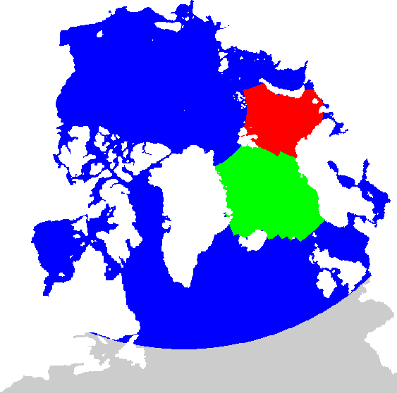
Regions
The ocean circulation model used in Copernicus Marine Arctic MFC covers the Arctic Ocean, the North Atlantic Ocean and adjacent ocean regions. The northern part is depicted in the figure below. Validation of sea surface temperature from model results is performed for three domains:
- an extended domain indicated by the blue, green and red regions in the figure
- the Nordic Seas, shown as the green region
- the Barents Sea, depicted in red
ARC-MFC PHYS (TOPAZ)
The model results are produced with the TOPAZ ocean data assimilation model system. Presently, TOPAZ is run weekly with data assimillation one week prior to the bulletin date, then applying a one-week 100 member ensemble simulation ending on the bulletin date. Then, for each day a 10 day deterministic forecast is produced. TOPAZ was developed and is maintained by the Nansen Center.
For the validation of near-surface drift, model results for ocean velocity at the 15 meter level are used. This corresponds to the representative depth for the drifters, which has a drogue centered at this level.
ARC-MFC PHYS (TOPAZ) results are available as Copernicus Marine product ARCTIC_ANALYSISFORECAST_PHY_002_001 from the Copernicus Marine Data Store. An archive of historical forecasts are available from a thredds server.
